About Walk-in Recruitment of JRF at IIRS – www.iirs.gov.in , ISRO – Nov 2015 :
Indian Institute of Remote Sensing (IIRS), – www.iirs.gov.in – a unit of Indian Space Research Organisation (ISRO), is a premier institute for capacity building and research in the field of remote sensing and geoinformatics. The Institute has a multi-disciplinary and problem oriented research agenda focusing on developing land-ocean atmosphere applications and understanding Earth’s surface and subsurface processes using primarily the space-based technologies. The research programmes are intricately linked to overall goal of ISRO towards operationalization of spacebased services for national development.
Young and motivated candidates are invited for the Walk-in interview for the post of JRF under the following research projects:
(1) Remote Sensing based hydro-meteorological data assimilation in the hydrological and weather forecasting models (EOAM Project).
- No. of Post: 1 (one)
- Essential Qualification: M. Tech in Agriculture Engineering / Civil Engineering / Computer Sciences / Remote Sensing / Geomatics or M. Sc in Meteorology / Atmospheric Sciences / Geo-informatics with at least two subjects from Hydrology / Mathematics / Physics at graduate level. The candidate shall be NET or equivalent* qualified in the relevant subject.
- Desirable Qualification: Candidates with Post-Graduate Degree or Diploma in Water Resources/ Remote Sensing / Geo-informatics with Hydrology as specialization from reputed university / institute in India / abroad, work experience in retrieval and assimilation of hydro-meteorological parameters from remote sensing, work experience with WRF, WRF-DA and VIC models and computer programming skills (C++, Matlab, Python, Grads, NCL and IDL) with knowledge of Linux will be given preference.
- Duration: upto 31st March 2016.
(2) Monitoring and Assessment of Ecosystem Processes and Services in NorthWestern Himalaya: Modeling temporal and spatial pattern of North Western Himalayan cities (EOAM Project)
- No. of Post: 1 (one)
- Essential Qualification: Master’s degree in Urban Planning / City Planning/ Regional Planning/ Remote Sensing and GIS/ Geoinformatics/ Geomatics/ Geography (M.Sc.) with B.E Civil/ B. Arch/ B. Plan/ B. Sc Geography at graduate level. The candidate shall be NET or equivalent* qualified in the relevant subject.
- Desirable Qualification: Candidates with computer programming skills (Python, Matlab, IDL, etc.) and experience in use of Remote Sensing and GIS will be given preference. Duration:
- The fellowship will be offered initially for a period of one year, which can be extended further till the duration of the project (likely upto 2018) depending on the performance of the candidate.
(3) Automatic Retrieval system and monitoring of water, vegetation and build up at variable scales using remotely sensed images.
- No. of Post: 1 (one)
- Essential Qualification: M. Tech/ M. Sc in Geoinformatics/ Remote Sensing/ Geomatics or equivalent with BE in Civil/Electronics/Electrical/Computer science/IT or M.Sc Physics/ Mathematics/ Computer Science/ Applied Mathematics. The candidate shall be NET or equivalent* qualified in the relevant subject.
- Desirable Qualification: Candidates with Diploma/working experience in Remote sensing/ Geoinformatics/advanced image processing tools and computer programming skills (C, C++, Matlab, IDL, Python, etc.) will be given preference.
- Duration: 3 years (1st April 2014 to 31st March 2017)
(4) Soil – Vegetation – Atmosphere Flux Monitoring (National Carbon Project)
- No. of Post: 1 (one) Essential Qualification: M.Sc in Agriculture Physics / Agriculture Meteorology / Plant Physiology / Agronomy / Enviornmental Science / Ecology OR M. Tech Remote Sensing & GIS with specialization in Agriculture/Ecology. The candidate shall be NET or equivalent* qualified in relevant subject.
- Desirable Qualification: Knowledge of statistical/mathematical data processing and computer programming. Diploma in Remote Sensing & GIS applications.
- Duration: The fellowship will be offered initially for a period of one year, which can be extended further till the duration of the project (likely upto 2018) depending on the performance of the candidate.
(5) Soil Vegetation Atomosphere Carbon Flux Monitoring (National Carbon Project)
- No. of Post: 1 (one)
- Essential Qualification: M.Sc in Botany / Ecology / Plant Physiology / Agriculture Meteorology / Forestry / Enviornmental Science / Atmospheric Science OR M. Tech in Remote Sensing & GIS with specialization in Ecology / Forestry / Enviornmental Science / Atmospheric Science. The candidate shall be NET or equivalent* qualified in relevant subject.
- Desirable Qualification: Knowledge of statistical/mathematical data processing and computer programming. Diploma in Remote Sensing & GIS applications.
- Duration: The fellowship will be offered initially for a period of one year, which can be extended further till the duration of the project (likely upto 2018) depending on the performance of the candidate.
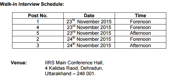
Walk-in Details :


